
Magnet, The
Date: 1950
Director: Charles Frend
Production Company: Vic Films productions Limited
Stars: Stephen Murray, James Fox, Kay Walsh
Location(s): Lancashire, London
Region(s): London M-N, North
Storyline:
A small boy steals a magnet and accidentally becomes a hero.
Additional Information:
Following the postcard Now shots sent in by Ray Jones from his personal archive he subsequently supplemented those with a rather amusing story of his “scally days”, with more pictures from his archive. Read article.

As an Amazon Associate, we earn from qualifying purchases.
Can you help:
If you have any information regarding this production, the locations or, even better, some comparison shots please contact us. Images submitted must be in Landscape orientation, as would be seen on the cinema screen, not Portrait.
We are aware that there are films on the site that were added when the criteria for the inclusion of locations was very different from today and, as a result, there may be scenes missing from some productions. Please do not forward additional screen captures to us but bring the detail to our attention, for we do, and are, 're-addressing' these older entries as time allows.
- Capture 1
- 'Now' required

Title showing Liverpool Cathedral. These pulls, snips, grabs or then pics were all gathered by Charles Blackman.
- Capture 2
- 14 Feb 2011

A street in the Wirral, maybe Widnes? But which? I think the family might have lived in Penkett Road Wallasey but I'm still not certain, maybe some shots are of the Grove Road area of Wallasey Village, Brian Say, imdb site.

This is actually in Park Hill Ealing London W5. John Owens discovered it.
- Capture 3
- 14 Feb 2011

Another view of probably, the same street, with some distinctive architecture.

The other side of the road (Park Hill, Ealing, London) - James Robertson Justice as the tramp. John Owens with the pic.
- Capture 4
- 14 Feb 2011

Wall detail.

James Fox chalking the 'secret language of tramps' on the gatepost. John Owens.
- Capture 5
- 14 Feb 2011

More wall.

Distinctive wall. John Owens again.
- Capture 6
- 01 Mar 2015

This is the old ramp leading to the Mersey Ferry. Good social history stuff, and with the two actors.

From Ray Jones' archives. One can see the main pier through the steel stanchions. Clearly visible is the 'hut' on the landing stage, as mentioned in mg007. See below for more from Ray. (SJ)
- Capture 7
- 01 Mar 2015

Harbourmaster's (?) hut, ferry side.

The landing stage and pier were located right on the round white building, center/bottom, in this Google Map close up. Fort Perch Rock can also be seen at the top of the marine lake. Thank you Ray. (SJ)
- Capture 8
- 01 Mar 2015

Pier head, Ferry jetty?... mg008 is not the Mersey Ferry floating landing stage at the Pier Haed, Liverpool. It's actually the same thing, only on the other side at New Brighton. Notice the far background. No liverpool side large buildings, but you can just make out the sea wall of the marine lake. You would be looking , roughly, in the mg023 direction. Ray Jones

And Ray sent this postcard in to prove his case. (SJ)
- Capture 9
- 21 Nov 2019

This is Mount Avenue in Ealing advises John Owens. The location was also used in 'The Long Memory'.
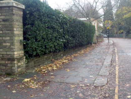
Antony Blair replaces John's Google image with this original.
- Capture 10
- 14 Feb 2011

The name of the property is 'Devon Cottage' which dates from 1796. It's still there though the original sign has gone. It's marked 'Devon' on one of the gateposts - with 'Cottage' on another gatepost further down.

John provides this modern comparison.
- Capture 11
- 21 Nov 2019

This house next door has been demolished - so no 'now' photo. John Owens.
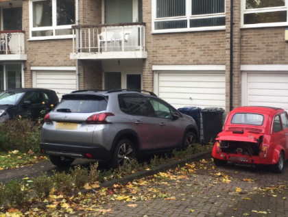
Replacing a John's Google image, Antony took this shot of the modern townhouses that now occupy the site.
- Capture 12
- 14 Feb 2011

Mount Avenue, Ealing W5.

Now shot of Mount Avenue by John Owens.
- Capture 13
- 14 Feb 2011

Mount Avenue again.

Another photo of Mount Avenue, taken by John Owens.
- Capture 14
- 21 Nov 2019

The house and wall have been demolished advises John Owens.
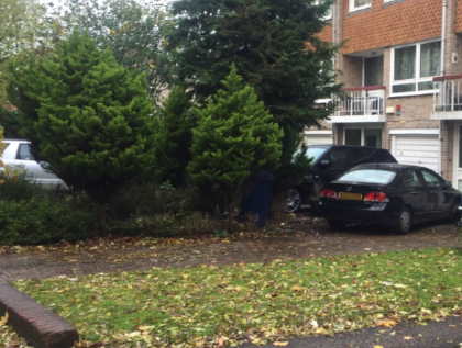
And this is what stands in the location today. Picture by Antony Blair.
- Capture 15
- 21 Nov 2019

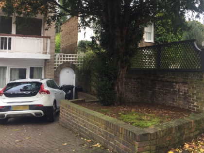
The same location now, replacing John's Google shot. Antony points out that the big house and extension are lurking behind the tree.
- Capture 16
- 21 Nov 2019

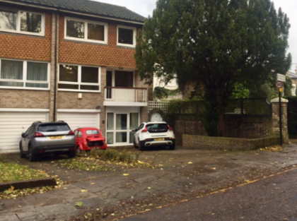
Antony again replaces John's Google image with this comparison.
- Capture 17
- 24 Dec 2018

The old pier at New Brighton, now long gone.

Andy Barr provides a shot from the same position minus the pier and a sand build up hiding most of the rocks. (RL)
- Capture 18
- 31 May 2010

Now we're cooking with gas. As they used to say. New Brighton, the view from Ham and Egg Parade, now called Marine Parade, of Fort Perch.

The location is well known - Fort Perch Rock in New Brighton - but this is a now shot just for the record. Thanks to John Owens for this.
- Capture 19
- 24 Dec 2018

Gone!

Another shot from Andy revealing the lost pier. (RL)
- Capture 20
- 24 Dec 2018

Railings at New Brighton.

This shot from Andy witnesses the loss of steps, replaced by rocks. (RL)
- Capture 21
- Pre 2008

Is that Mr Bridges and Pat Roc from "Millions Like Us" looking over the railings?

Now, with the steps gone.
- Capture 22
- 24 Dec 2018


Andy proves that the steps really have gone. (RL)
- Capture 23
- 01 Mar 2015

Gone.

An archived image from Ray Jones and, Ray adds, as a young scally from Liverpool, some mates and I actually walked around the track of the (then derelict), New Brighton big dipper....mad! (SJ)
- Capture 24
- Pre 2008

Marine Parade.

Now. The balls get the prize and almost the same ice cream van. Well done Charles.
- Capture 25
- Pre 2008

Fort Perch Rock.

Now. Perch Rock Fortress. Charles took the pic.
- Capture 26
- Pre 2008

Marine Parade.

As pic 23. Same place, different angle, so no prizes.
- Capture 27
- Pre 2008

The Amusement Park, Marine Parade, New Brighton.

Now. Really still the same place. Thanks Charles.
- Capture 28
- 25 Jan 2010

An alleyway, perhaps in old New Brighton? Rowson Street, New Brighton. Alley way runs into Duke Street or if further, Grosvenor Road. Alan sent this in.

An alley, only missing Sally. Perhaps Alan knows her?
- Capture 29
- Pre 2008

Another alleyway, but this time next door to Redcaps, Victoria Parade, New Brighton.

Now. Very probably, but a pan shot.
- Capture 30
- Pre 2008

Birkenhead Brewery. And those Sins again. Beware those whose promises are not kept!

Redcaps, now being tarted up, and Victoria Parade used to be called King's Parade. Picture from Charles Blackman. Whoever said that mg030n is Redcaps now being tarted up has it wrong. This building was formerly the Ferry Hotel which later became a club called The Chelsea Reach. It has now been converted into apartments. Redcaps, the former pub called the Criterion, was on the other side of the alleyway. Welcome correction from Alan.
- Capture 31
- Pre 2008

The Liver Building, comes under our "stately home/public building" category. Public/famous buildings that are easily recognisable. No prizes for this one, even I got it.

Now. Recognisable "stately home/ public building". Thanks Charles but no premium.
- Capture 32
- 30 Dec 2009

The scene in a park on top of the hills when he plays with a kite is Harrison Drive Park. The old cricket Pavilion is in the back ground, this has been relaced with a more modern rather ugly building. When he runs off after the couple sit on the bench he runs towards the Warren Golf course. Brian Say, imdb site.

Harrison Park in New Brighton - the landscaping in the park has changed and the cricket pavilion has been replaced by a 'box' type structure - but this is as close as possible to the original Found and photo'd by John Owens, thanks to him.
- Capture 33
- 25 Jan 2010

At the back of mg038. It says "R W Burgess - Houses" on the house at the back. An Estate agent? A clue? What would Jack Frost or Hercule Poirot make of it, or even Albert Finny in "Gumshoe"? Probably Sea Road, Wallasey. Alan again, many thanks.

Now. Snapped by Alan. John Owens also found this site, but a couple of days too late.
- Capture 34
- 25 Jan 2010

Grove Road, corner of Sea Road, Wallasey. Alan identified the location.

Nice bit of red brick, from Alan. John Owens also came a close second with this one as well, but there are plenty of other shots to identify in this film.
- Capture 35
- 25 Jan 2010

Kirkway / Mount Pleasant Road, Wallasey. Sleuthed by Alan.

Another good 'un from Alan.
- Capture 36
- 25 Jan 2010

Mount Pleasant Road, Wallasey. And Alan found this one as well.

The super sleuth with the Mersey beat, Alan again.
- Capture 37
- 30 Dec 2009

The old Court House on Manor Road Wallasey and still looks the same today. Brian Say, imdb site.

The Old Court House on Manor Road, Wallasey has not changed - is now used by Wirral Council, John Owens tells us, and he took the pic as well.
- Capture 38
- 30 Dec 2009


The estate agents on the corner of Manor Road/Queen Street, Wallasey is now a residential property but otherwise hasn't changed. Sleuthed and spotted by John Owens.
- Capture 39
- 21 Nov 2019

Junction of Kings Road and Park Hill, Ealing. The corner stones of the wall are the same today and the lamp structure at the junction of Park Hill and Mount park Road can be seen behind the parked car. Identified by Vic Pitcher.
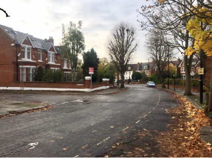
Antony Blair captured Autumn's leaves at the same location.
- Capture 40
- 14 Feb 2011

This should be easy.

This house is not in the Wirral - but in Park Hill Ealing (where else ?!). It can be identified for sure by the distinctive door arch and windows and markings above the door and windows. The glass panel above the door is also still there. John Owens.
- Capture 41
- 12 Mar 2017

Now a butchers at the bottom of the Mount Pleasent Road but im still not 100% certain Brian Say, imdb site.

Neither was I. In fact 233 Seaview Road, Liscard, Wallasey and by the looks of it from this Google Earth shot it is exactly the same drain pipe. (RL)
- Capture 42
- 12 Mar 2017

Next door to mg041

In fact Edwards "Fancy Drapers" at 229 and 231 Seaview Road, Liscard, Wallasey. This Google Earth shot witnesses that there has been no change to the window frontage. (RL)
- Capture 43
- 25 Jan 2010

This street was used in "Let Him Have It" I'm told. Longworths was a bicycle shop located at No 78 Rowson St New Brighton. Looking at the shop front you can see an alley way. This alley way leads to Duke St then and still as of today. Maureen Pennisi (nee Cooper) who used to live in number 68 Rowson St. Longworths cycle shop, Rowson Street, New Brighton. Alleyway he ran down is at the side but he comes out by the ferry hotel which is/was impossible. Says Alan.

The shops are long gone and you can now see new houses. This was a well known cycle shop and had a train set in the window. If you put a penny in the slot it made the trains go. I can never remember anything in the alleyway that looks like that fenced off thing so it could have been put there for the film or maybe it was done away with not long after I came on the scene. Alan.
- Capture 44
- 18 Jul 2015

Site visitor Simon Rothwell has provided a location correction for this shot. The kids are running down the alley way with Rowson Street, New Brighton, Wallasey CH45 2LX, behind them. Alan had already correctly pointed out that the alleyway is at side of Longworths shop mentioned in capture 43.

Proof from Maureen of the film unit in action, researched all the way in Australia from a former Liverpudlian. A reverse POV to the screen capture. (SJ)
- Capture 45
- 17 Dec 2018
A repeat of Capture 44 (RL)

Andrew Barr provides this shot of the same location today. (RL)
- Capture 46
- 'Now' required

Carl Rosso suggests this shot was taken in Albion Street in Wallasey. This is in the entrance to what was Billy Dunning's MOT garage up until about 10 years ago (which would be around 2008). It is directly opposite The Clarence pub, but the gateway has since been built across.
- Capture 47
- 25 Jan 2010

Alleyway at back of the Rowson street shops. Alan again with local knowledge.

A load of old cobbles! Well spotted Alan.
- Capture 48
- 12 Mar 2017

Ray Glenister does not agree with the "now" shot 046n. The screen capture shows the rear of houses at the end of the alley. In reality the Sandrock Hotel stood at the end of the alley which had a different rear and roof line. (RL)

An extract from "Britain from Above" showing the rear of the Sandrock Hotel. (RL)
- Capture 49
- 05 Apr 2012

Liverpool Cathedral in the distance. Jordan Street. When I last looked, the building next to the parked car was still there, but had trees growing out of the windows. Mike Bradford

Now. Well done Charles. But "stately home", but thanks all the same.
- Capture 50
- 03 Jun 2017

Ray and Ron Glenister are concerned that the existing "now" shot is from the wrong side of the Cathedral (RL)

And provide this Google Earth capture to set the record straight. (RL)
- Capture 51
- 05 Apr 2012

Playing cricket on the bomb site. Didn't we all!

Now. Look at the church tower spires in the distance. Liverpool view by Charles Blackman. A strong probable, so, another tenner for his efforts. The church is St Lukes, which was bombed during the war. The picture is on Rathbone Street, with Rathbone Place on the left. It is all under the cathedral close now, so you can't see as far as the church. Mike Bradford
- Capture 52
- Pre 2008

The bomb damaged area near the cathedral.

Now. From the Cathedral Close area of new housing, Liverpool.
- Capture 53
- 13 Jan 2016

Cathedral again... could be Alfred St where I lived long since demolished says Mike Marsden.

Now, from Cathedral Close.
- Capture 54
- Pre 2008

Perhaps Victoria Parade. Many of the shops were arcaded. Most have long since perished. It was never called Victoria Parade but Victoria Road. Says Alan.

Now, again. Look at the red bay window on the right and the inverted "V" and arch on the windows on the left. Proof enough I think for thanks to Charles.
- Capture 55
- 25 Jan 2010

This was unique and nothing to do with the modern photograph. The place they are standing outside of was the public lavatories, information office and a shelter. Above it was the Avondale cafe and you could sit out on the terrace in good weather. Alan tells us this.

Copyright free image from Alan, the bay windows between the two men are the architectural proof. Well done Alan.
- Capture 56
- 24 Dec 2018

From the same series of photographs as appears as Capture 44 "now". Provided by Andy Barr, we fully acknowledge any Copyright if there is any, reiterate our Statement included in "How to Submit" and appreciate the fact that Capture 44 "now" has been on Site since 2015. (RL)

Andy provides this shot of the same location now advising that the building to the left is a petrol station. (RL)
- Capture 57
- 24 Dec 2018

From the same series of photographs as appears as Capture 44 "now". Provided by Andy Barr, we fully acknowledge any Copyright if there is any, reiterate our Statement included in "How to Submit" and appreciate the fact that Capture 44 "now" has been on Site since 2015. (RL)

Andy took this shot from what is now a petrol station forecourt clearly showing the background building as it is now. (RL)